By: Herman Broers, Maritime Pilot, Port of Rotterdam Date: September 1st, 2021
Abstract
Within the context of E-navigation, several concepts have been developed which could revolutionize the handling of traffic at sea and in the port. Several conditions, including the improved connectivity with ships, still must be filled in to achieve this. The goals of E-navigation are clear: improved efficiency, sustainability, reduction of greenhouse gas emissions and increasing safety at sea and in coastal states. This paper explores the possibilities for the Dutch maritime pilot and their organization to play a role within the domain of E-navigation. Based on the existing developments regarding E-navigation and the competences of the maritime pilot, an analysis is made as to what the pilot’s contribution to E-navigation could be, both in narrow and restricted pilotage waters and beyond. E-navigation developments have a large impact on the maritime pilot’s profession. At the same time, it is concluded that these developments could potentially strengthen the maritime pilot’s profession and organization in the future.
Abbreviations
AR : Augmented Reality
EMPA : European Maritime Pilots Association
Enav : E-navigation
ETA : Expected Time of Arrival
FSA : Formal Safety Assessment
HUD : Head Up Display
IALA : International Association of Lighthouse Authorities
IMO : International Maritime Organization
MMP : Master in Maritime Piloting
NSR : North Sea Region
PEC : Pilot Exemption Certificate
PPU : Portable Pilot Unit
RCO : Risk control option
RLc : Regional Maritime Pilots Association
SBP : Shore Based Pilotage
SIP : Strategy Implementation Plan
TSS : Traffic separation scheme
VTS : Vessel Traffic Service
Framing
The elaboration of this paper is based on the knowledge, skills and tasks of the Dutch maritime pilot, which is comparable to those of his European colleagues. The analysis of the use of E-navigation in this paper will be based on a European maritime context. E-navigation initiatives developed within Europe will be considered in the elaboration of this document.
1: The Maritime Pilot
1.1 Legal basis
Pilotage is laid down in Dutch law within the shipping act, Article 10.1:”The master is obliged to use the services of a pilot during the voyage of the seagoing vessel on the shipping lanes indicated in the annex to this Act”. The unique position of the pilot lies in the fact that he is authorized to advise the master on the navigation to be carried out. By means of laws, regulations and decrees, a system has been provided in which the Netherlands Maritime Pilots Association (NLc) has been designated as an independent self-governing body that organizes pilotage in the Netherlands. The NLc is responsible for training maritime pilots, promoting proper professional practice, professional competence and providing information about the same. (Overheid.nl, 2012)
Compulsory pilotage is a means for the maritime authorities to ensure that marine traffic in each harbor region runs safely and smoothly. There are several other instruments to achieve this, such as the presence of a nautical harbor master organization, a traffic control system, and a system of pilot exemption certificates.
There are four pilotage regions, each with its own Regional Pilot Corporation, or RLc. RLc’s are public organizations of which every registered pilot is a member to offer his services. The boards of the RLC’s have the task of maintaining and training enough pilots and promoting good professional practice.
The pilots themselves are collectively responsible for the efficiency of the pilot service. Maritime Pilots are commercially connected by means of partnerships. Also, they are shareholders of the supporting company, Nederlands Loodswezen B.V.
1.2 Maritime Pilots Training
Candidate maritime pilots are selected from deck officers with a bachelor professional maritime education background, in possession of the certificate “master all ships”. The course for maritime pilot is master-accredited.
The trainee pilot first follows a national training of two months with the emphasis on themes and skills that are not region-specific. The subjects that are discussed during the central MMP training are: general laws and regulations, buoys and tides, communication, maneuvering in theory and practice, research and development, organizational science, shipping regulations, theoretical and practical maneuvering, and safety Aspects.
Next, a regional training follows within the pilotage area of the pilot. This training consists of a theoretical part, in which attention is given to regional themes and skills. The subjects covered during the regional course are general laws and regulations, local port- and shipping regulations, geography, tidal knowledge, communication procedures, safety aspects, practical and theoretical navigation and maneuvering, MRM, economics and research and development.
In addition to the theoretical part, the student will join 200 pilot trips for 13 months, each of which will be assessed by the accompanying maritime pilot. Upon successfully completing this training course, the student will be enrolled as a maritime pilot in the national pilotage register.
1.3 Additional training
The new pilot will have a pilot license for small ships only. During his career, the pilot needs to follow several mandatory repeat training courses as he grows in his pilot’s license, and in the size of ships he is allowed to pilot. In addition, specializations are possible which allow him to pilot certain types of ships in special sailing areas. Training for performing ancillary functions is required when needed.
Some examples of the additional education and trainings are: specialization for sailing oversized ships in various geographical areas, LNG awareness training, azipod training, VTS-training, SBP-Training, bridge and lock training, chief Pilot, helicopter safety and helicopter underwater escape training (HUET), instructor training.
1.4 Knowledge areas of the pilot and their organization
The pilot is a maritime specialist, who, through his education and experience, possesses several specific fields of knowledge and skills. The pilot and his pilotage organization focus on the following areas:
• Advisor of the captain
• Local knowledge (Geography, Hydrography, Meteorology, Traffic patterns)
• Maneuvering with ships, use of tugs and boatmen
• Marginal vessels (UKC, size and windage area)
• Bridge and lock transits
• Vessel traffic service (VTS) – tasks
• Shore based pilotage (SBP) – tasks
• Planning of shipping
• Development of navigation software
• Consultancy
These focus areas will be included in the analysis of the influence of E-navigation developments on the pilotage profession and pilotage organization.
2: E-Navigation
2.1 Definition
On the IMO website, E-navigation is defined as follows:
” The harmonized collection, integration, exchange, presentation and analysis of marine information on board and ashore by electronic means to enhance berth to berth navigation and related services for safety and security at sea and protection of the marine environment.”” (International Maritime Organization, 2019)
2.2 IMO Strategy Implementation Plan (SIP)
The IMO has defined a Strategy Implementation Plan (SIP), with five pillars in the form of so-called solutions (“E-navigation Solutions”) that will be developed: (E-navigation strategy implementation plan – update 12018)
S1: improved, harmonized, and user-friendly bridge design.
S2: means of standardized and automated reporting.
S3: improved reliability, resilience and integrity of bridge equipment and navigation information.
S4: integration and presentation of available information in graphic displays received via communication equipment; and
S5: Improved communication of VTS Service Portfolio.
These five pillars are not static. Member States are encouraged to create new pillars and to actively provide input to keep the content of the different pillars up-to-date and to improve them. During the establishment of the five pillars, several Risk Control Options were defined during a formal safety assessment (FSA) process, which was used to support the creation of the pillars. These RCOs are:
• RCO 1: Integration of navigation information and equipment, including improved software quality assurance
• RCO 2: Bridge Alert Management
• RCO 3: Standardized mode(s) for navigation equipment
• RCO 4: Automated and standardized ship-shore reporting
• RCO 5: Improved reliability and resilience of on-board PNT systems
• RCO 6: Improved shore-based services
• RCO 7: Standardization of bridge and workstation layout
RCO 3 touches on the work of the maritime pilot as he uses the navigation equipment on board. RCOs 4 and 6 will have a direct impact on the work or the organization of maritime pilots.
So-called maritime services must ensure a harmonized digital information exchange between shore and ship. For this purpose, six areas have been designated within SIP:
- Port areas and approaches.
- Coastal waters and confined or restricted areas.
- Open sea and open areas.
- Areas with offshore and/or infrastructure developments.
- Polar regions; and
- Other remote areas.
The scope of the working area of the maritime pilot is currently limited to the areas under (1) and (2).
In conclusion, the concept of E-navigation, as laid down by the IMO, has common ground with the work and organization of the maritime pilot. The evolution of E-navigation will therefore have an influence on the pilot profession and the pilot organization.
2.3 Relevant E-navigation Initiatives from the European Union (EU)
Below are several European E-navigation initiatives that are relevant for the future implementation of E-navigation and have common ground with the work or expertise of pilots.
ACCSEAS: (2012-2015)
Under this project, which aimed to demonstrate the general necessity of E-navigation in the NSR, the first steps were taken to come to a plan of what E-navigation should look like. The following items and initiatives relevant to pilotage have been identified: (IALA, 2021a)
• Maritime Cloud as an underlying technical solution
• Backup for ship positioning such as R-Mode and eDLoran
• Maritime safety information/notifications to mariners (MSI/NM)
• No-Go-Area Service
• Tactical exchange of intended route (ship /ship and ship / shore)
• Augmented Reality / Head-Up Displays (HUDs)
• Harmonized data exchange
• Real-time vessel traffic pattern analysis and alert functionality for VTS
Avanti/ Pronto (2015-2016)
Port Call Optimization, the reduction of ship time in port and improvement of usage, improvement of event data, use of the same language and formats in reports. This project is managed and commercialized by the Port of Rotterdam Authority. (PortXchange. 2021)
Efficiensea (2009-2012)
The objectives of this project are defined as follows: (Efficiensea. 2013)
• Sharing of intended routes via the ship’s transponder
• Presentation of intended routes of other ships on ECDIS
• Sharing of suggested routes from shore (e.g., VTS) to a specific ship
• Display of the proposed route on the ship’s ECDIS
Efficensea2 (2015-2018)
EfficienSea2 creates and implements innovative and smart solutions for efficient, safe, and sustainable traffic at sea through improved connectivity for ships. EfficienSea2 is a demonstrator in the Arctic and the Baltic Sea and the first generation of a coherent e-Navigation solution. Through global collaboration, use of open-source software and an explicit goal for standardized solutions, it is paving the way for a global rollout of e-Navigation through the development of the Maritime Cloud. (Efficiensea. 2013)
Ionio (2012-2013)
The IONIO project aims to design and implement an “IONian Integrated marine Observatory” that will provide environmental information and meteo-oceanographic measurements on the southern Adriatic and North Ionian program area. It offers users a (semi) automated routing proposal based on the latest hydro-meteo information.
Mona Lisa 1.0 (2010-2013)
This project involved dynamic and proactive route planning through the sharing of route planning at a strategic level by ships with shore stations. (IALA, 2021b)
Monalisa 2.0 (2013-2015)
Standardized route exchange between shore-ship and ship-ship using the European Maritime Simulator Network (FSA) (IALA, 2021c)
Sesame Straits Project (2014-2017)
Developing and validating Ship Traffic Management System (STMS) based on shared situational awareness and decision-making between bridge team and shore-based services. The VTS provides a platform for tactical and strategic planning. This includes new operational services such as: (SESAME straits e-navigation test bed project. 2016)
• Just in time arrival advice: Up to a few days before arrival of the ship.
• Optimal cruising speed: To reduce greenhouse gas emissions.
• Efficient flow through narrow and limited UKC waterways.
• Better use of port facilities such as anchorages, berths, pilots, etc.
STM-Validation (2015-2018)
In this project, the focus was on validating the optimization of the ship’s voyage in the port and coastal waters. (STM – sea traffic management. 2021)
• Validation of port collaborative decision making to optimize port lead time.
• Validation of Voyage Management tools.
• Validation of Flow Management (flow optimization) on simulators
• Validation of common maritime service infrastructure through a common maritime cloud.
2.4 E-navigation developments in Dutch pilotage
GIDS
In collaboration with other nautical service providers, the Rotterdam pilots have developed a platform in which the pilots, boatmen and towing services can coordinate their operations. By aligning the capacity of service providers, waiting time for ships and service providers is reduced and users and the nautical authority gain insight into ETAs of ships sailing within the port. The platform also serves as a reporting system for all nautical service providers. (Gids – loodswezen. 2021)
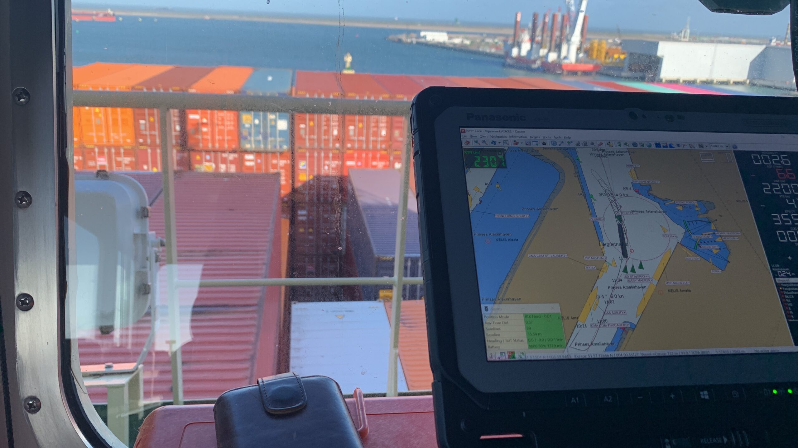
Development of PPU and navigation support software
In recent years, the pilot organization, together with manufacturer QPS, have renewed the software of Portable Pilot Units (PPUs) and laptop and iPad based navigation support software. This system informs the pilot about the traffic image in the port, not only via the ship’s AIS pilot plug, but also via a direct link (4G) with the traffic control system (VTS). Actual hydro-meteo information is presented in the software. Changes in ENCs are transmitted wirelessly to the pilot, so that he has the latest depth charts of the port at all time. (Qastor – QPS. 2021)
2.5 E-navigation developments outside Dutch pilotage
VTS of the future / Tomorrow’s traffic center
Both the government and the Port of Rotterdam Authority (HBR) are currently developing new concepts to modernize and optimize traffic management from shore. Concepts from the E-navigation initiatives are considered. (VTS | port of Rotterdam | digital lab. 2021)
Renewal of Pilot’s Act
The renewed pilot’s act will enter into force on 1 January, after a legislative process of 8 years. During the consultation rounds that were part of this process, the users of pilotage services indicated that they expected a lot from technological solutions and shore-based pilotage. It indicates that the progressive end-users say they are ready for a step forward that follows along the lines of E-navigation. (Parlementaire monitor, 2021)
Up-to-date hydro/meteo information online (NAIADE)
Port of Rotterdam recently published its hydro-meteo sensor data online. This makes validated information about the weather and water conditions available to all users in the port in a transparent, unambiguous manner. It serves as a primary source of information for the port accessibility policy, e.g., when determining tidal windows for marginal ships. (Port of Rotterdam, 2021)
Route advice container ships near Wadden Islands
Following the MSC ZOË disaster on the 2nd of January 2019, the Dutch coastguard is now providing route advice to large container ships sailing the traffic systems north of the Frisian Islands. Above a certain wave height, large container ships are advised to take a more northerly route. This is an interpretation of previously developed E-navigation concepts in the context of, among other things, EFFICIENSEA.
3: Influence of E-Navigation on pilotage profession and organization
To map the impact of various developments on the maritime pilot and his organization, both have been compared to each other in table 1. This assumes that all the developments mentioned will be realized in the future.
Item 1: Standardized mode(s) for navigation equipment: The introduction of standardized modes for navigation equipment will positively influence the primary task of the pilot, advising the captain. It will have a direct influence on maneuvering, sailing marginal ships and passing bridges and locks, because it obtains the navigational data it needs in a simple, unambiguous manner. When performing VTS tasks, or when performing SBP services, he knows what information the captain has “in front of him”.
Item 2: Automated/ standardized ship-shore reporting: An automated or standardized reporting between shore and ship primarily benefits the optimization of the processes around the planning of ships. Not only regarding arrival information, but also, for example, for the early ordering of nautical services such as pilots, boatmen and towing services. These nautical service providers can optimize their own processes using this information.
Table 1: Influence of E-Navigation developments on pilotage
Table 1: influence of E-navigation developments on pilotage
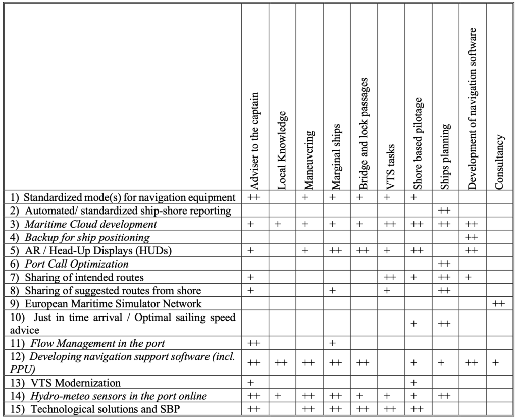
++ High Impact; + Low Impact; [Empty} No Impact;
Italic : in development by / with Dutch pilots
Item 3: Maritime Cloud development: When maritime Cloud development is used for sharing operational information between shore and ship, this has a major impact on ship planning and the handling of traffic in the ports and therefore also on the work of the pilot. Warehouses already use Cloud solutions themselves to obtain their own PPU-related information. The benefits that are obtained from this may soon also benefit the ships they serve. Of course, this also has an influence on remote piloting and VTS tasks that are performed from the shore.
Item 4: Backup for ship positioning: In 2014, the Rotterdam pilots demonstrated that the use of eDLoran can be a good alternative to GPS. (Buuren van et al., 2014) Shortly after, the Loran signal was decommissioned. Nevertheless, disrupting the GPS signal is a very real risk, even in the Netherlands. (Belga, 2021) Pilotage has an interest in solving this problem because it is of great importance that a robust precision navigation system is available for navigation with marginal ships.
Item 5: Augmented Reality / Head-Up-Displays (HUD’s): Augmented Reality (AR) can be a useful addition to efficient navigation. The developments of AR and HUD displays are still in a very early stage, but they will affect navigation on board, as well as the use of VTS systems in remote pilotage in the future.
Item 6: Port Call Optimization: In contrast to many E-navigation concepts that are only slowly getting off the ground, many initiatives have now been developed to optimize the process around the stay of ships in port. Ports have a commercial interest in a smooth flow, which means that new customers and cargo flows can be attracted. That is why huge budgets are available for initiatives such as PortXchange. Pilots have now demonstrated that they can participate in this successfully. This concept mainly affects the ship’s planning.
Item 7: Sharing of intended routes: Sharing intended routes by ships will affect the pilot’s primary task: advising the captain. Especially in ports with high traffic intensity, it is often impossible to predict in advance which route the ship will sail. However, sharing the intended route will be a useful addition, especially for VTS and SBP.
Item 8: Sharing of suggested routes from shore: The coast guard is currently giving advice to ships that sail the TSS to Hamburg. Should the initiative to structurally share proposed routes with ships come about to increase efficiency and safety at sea, the pilots could contribute to this from their experience of sailing with large or marginal ships. This concept will have an impact on the advice to the captain, sailing with marginal ships and of course also on the use of VTS and finally on the planning of ship movements.
Item 9: European Maritime Simulator Network: The creation of a European Maritime Simulator Network offers pilots the opportunity to actively participate in the development of E-navigation concepts with its own simulators.
Item 10: Just in time arrival/ Optimal sailing speed advice: This concept is intended to reduce emissions from ships in the North Sea. This development has an impact on the planning of shipping and the way in which SBP will be designed in the future. Sustainability is a spearhead of the pilot’s company policy statement, which is why this is an important spearhead to work on. (Loodswezen, 2021) Actively promoting “sustainable shipping” will have an impact on traffic planning in general.
Item 11: Flow Management in the port: The work of the chief pilot at the Port Coordination Centre largely comes down to planning oversized ships that are limited in port accessibility due to depth, length, or the nature of their cargo (e.g., LNG-carriers). Optimizing traffic flows in the port is also called “Vessel Traffic Management” or “Traffic Planning”. In each port, a form of traffic planning takes place to optimize the occupancy and use of the port. This of course directly affects the way in which the pilot does his work on board, because he is bound by certain restrictions during the voyage, such as tidal windows.
Item 12: Developing navigation support software (incl. PPU): For years, maritime pilots have developed their own tools in the field of (precision) navigation. Nowadays, precision navigation solutions are no longer exclusively available for pilots. Cruise ships, offshore vessels and large container ships are equipped with the same navigation equipment. Further development of precision navigation equipment on board ships will affect both piloting and the way in which VTS and SBP services will be provided from shore in the future.
Item 13: VTS Modernization: In the modernization of VTS-systems, several E-navigation initiatives as described will be integrated into their final implementation. This will lead to an optimized data exchange between shore and ships. As a result, both the navigation process of the pilot on board, as well as the VTS and SBP process on shore will be affected.
Sub 14: Hydro-meteo sensors in the port online: Placing the hydro-meteo sensors data online in the port of Rotterdam has ensured that all authorities, pilots, captains, and other users use the same information that is important for the admission policy and navigation in the port and off the coast. This very useful internet application has a large impact on the pilot’s profession.
Sub 15: Technological Solutions and shore-based pilotage: The development of technological solutions and the further development of the concept of SBP will obviously affect the way pilots do their work on board ships or possibly from shore. The question is what these solutions will look like and at what point these developments will be more effective and efficient than the current physical presence of pilots onboard.
4: Conclusions and discussion:
E-navigation goals are almost the same as those of the pilots, their organizations, or their mission statements.
E-navigation has an enormous impact on the pilot’s profession. The previous analysis shows that 6 of the 14 E-navigation developments are already being embraced or co-developed by pilots at local or national level in The Netherlands.
The further development of navigation equipment on board ships by means of standardization, AR and HUD displays needs to be explored. From their position as end users, pilots can contribute to this in a valuable way. It will ultimately also benefit the quality of their own services.
Optimizing data exchange between shore and ship will lead to more safety, increased efficiency, a more sustainable mode of transport and more insight from shore into the situation at sea/ onboard and from the ships into the situation in port.
The pilots could use their experience in navigating with marginal ships, in route advice in coastal area’s e.g., the North Sea. This would strengthen the position of the pilots and their profession, even outside the present pilotage waters.
As a user of VTS, both as a customer and as shore-based pilotage operator, it is of great importance for the pilots to participate with the modernization of VTS chains at a regional and national level.
By using their own knowledge and skills and by using their own simulators, E-navigation ideas can be verified by pilots. This wil ensure the position of the pilot on the bridge is considered in decisions concerning E-navigation. It is important to join these developments and to think along with them.
Finally, a note on the technological solutions that some end users are apparently waiting for. The history of shipping shows that the development of revolutionary concepts like E-navigation are a long-term matter. Within the profession of pilots and beyond remote piloting solutions are still considered “second-best” compared to the physical presence of the pilot on board. If the pilots continue to be innovative and optimize their services using smart solutions in cooperation with maritime authorities, they will be able to continue to do their work on board. This could logically transition into SBP by pilots in the future.
Afterword
This paper was written as part of the E-Navigation module of the Master in Maritime Innovation course at NHL Stenden University of Applied Science, Willem Barentsz Maritime College at West-Terschelling, The Netherlands.
References
Belga. (2021, 7-3-). Dronekiller op luxejacht mogelijke oorzaak van verstoring scheepvaart op westerschelde. Niewsblad.Be https://www.nieuwsblad.be/cnt/dmf20210327_96327947
Buuren van, W., Dekker, C., Kellanbach, R. & Willigen van, D. (2014). eDLoran – next generation of differential loran. Resilient Navigation and Timing Foundation. https://rntfnd.org/wp-content/uploads/eDLoran-Reelektronica-Paper.pdf
Efficiensea. (2013). Efficiensea – Efficient, safe and sustainable traffic at sea. http://efficiensea.eu
E-navigation strategy implementation plan – update 1 (2018). . IMO.
Gids – loodswezen. (2021). Gids – loodswezen. https://gids.loodswezen.nl
IALA. (2021a). Accseas – iala aism. ACCSEAS – IALA AISM. https://www.iala-aism.org/technical/e-nav-testbeds/accseas/
IALA. (2021b). Monalisa 1.0 IALA AISM. Monalisa 1.0 IALA AISM. https://www.iala-aism.org/technical/e-nav-testbeds/monalisa-1/
IALA. (2021c). Monalisa 2.0 IALA IASM. Monalisa 2.0 IALA IASM. https://www.iala-aism.org/technical/e-nav-testbeds/monalisa-2-0/
International Maritime Organization. (2019). E-navigation (IMO). International Maritime Organization. https://www.imo.org/en/OurWork/Safety/Pages/eNavigation.aspx
Kustwacht.nl. (2020). Routeadvies containerschepen nabij waddeneilanden. Routeadvies containerschepen nabij Waddeneilanden. https://www.kustwacht.nl/nl/dossiers/routeadvies-waddeneilanden
loodswezen. (2021). Loodswezen – MVO. Loodswezen – MVO. https://www.loodswezen.nl/Over%20ons/maatschappelijk-verantwoord-ondernemen.aspx
Overheid.nl. (2012). Scheepvaartverkeerswet. Wetten.nl – Regeling – Scheepvaartverkeerswet. https://wetten.overheid.nl/BWBR0004364/2021-07-01
Parlementaire monitor. (2021). Wet actualisatie markttoezicht registerloodsen. Wet Actualisatie Markttoezicht Registerloodsen. https://www.parlementairemonitor.nl/9353000/1/j9vvij5epmj1ey0/vl1oiwwefrz4
Port of Rotterdam. (2021). Weather and tide. weather and tide. https://www.portofrotterdam.com/weather-tide/desktop/
PortXchange. (2021). Portxchange – Digital Collaboration Platform For maritime Logistics Chain. https://port-xchange.com
Qastor – QPS. (2021). Qastor – QPS. https://www.qps.nl/qastor/
SESAME straits e-navigation test bed project. (2016). SESAME Straits e-navigation Test bed project. http://straits-stms.com/Project.html
STM – sea traffic management. (2021). STM – Sea Traffic management. https://www.seatrafficmanagement.info
VTS | port of rotterdam | digital lab. (2021). VTS | Port of Rotterdam | Digital lab. https://lab.portofrotterdam.com/vts/